What Do You Think?
Thanks to Robin Allott for the above information and pictures
Some of the older Hill figures have shown some resemblance to Stellar Constellations.
Is it possible that there is some connection?
What Do You Think?
Thanks to Robin Allott for the above information and pictures
Terrestrial Triangulation
To follow this, you need a pencil, a ruler (straight-edge),
and a good map of the UK, showing the
South of England and the major archaeological locations.
THE THREE TRIANGULATION POINTS
The terrestrial triangulation of the Salisbury Plain, etc. by the prehistoric
peoples
of Britain utilized three major points (as "re-discovered" by Andis Kaulins).
All three of these points are (the now famous) gigantic chalk
figures - cut into the British countryside for this purpose. They are:
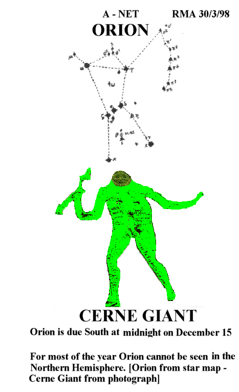
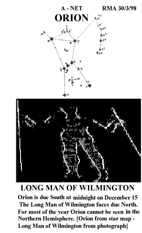
1. The Long Man (Dod-man, the star Djed-efre, kappa-Orionis) at Wilmington
(by Eastbourne) symbol for "The Surveyor" or "Measurer",
one stick in each hand.
2. The Cerne Giant north of Dorchester "Hercules & Ophiucus, the star Ras
Alhague", and
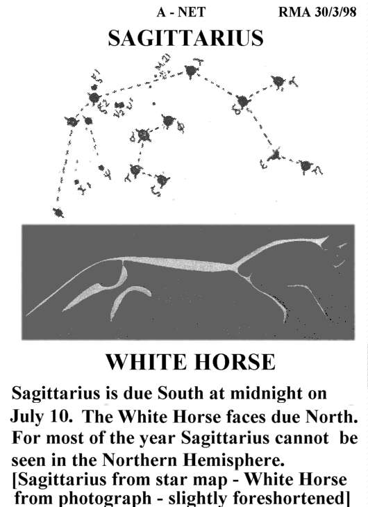
3. The White Horse ("Pegasus, the star Marked of the Great Square") at
Uffington, SW of Oxford.
Connecting these three points on a map of Great Britain gives a right
(90-degree) triangle, with the
hypotenuse (the longest side) running directly parallel to latitude 51 degrees
North at a distance just as far below the 51st parallel as Stonehenge is
above it.
You have to draw this yourself to appreciate its correctness.
THE RIDGEWAY
The location of the Ridgeway at the top of the 90-degree triangle makes sense
in light of the triangulation presented in Stonehenge - Prehistoric Survey 1.
What is the Ridgeway?
At Uffington, the White Horse (374 feet long) is cut into White Horse Hill
at the "highest" north point of a prehistoric "trackway" called
"THE RIDGEWAY",
which extends downward and East and West of Uffington
about 20 miles along the Berkshire Downs above the Kennet Valley
and follows the triangulation lines presented in Prehistoric Survey 1.
[The Ridgeway was re-opened as a publicly accessible footpath only about
25 years ago. Indeed, it is still missing on many geographic maps,
but is found, e.g., on the large Michelin Atlas of Britain.]
Since the White Horse is Pegasus, the archaeological location under that
is known as Wayland's Smithie and makes sense, as does the legendary
affiliation of a seven-bodied something with the city of Lambourn, which
stands
for the seven stars of the Pleiades, known in German, e.g. as the seven stars
(Siebengestirn).
"Lamb-born" actually meant the lambs born at the dawn of spring and the
Pleiades.
THE PORTWAY
The location of the Portway (Calleva Atrebatum, erroneously thought
to be a road of Roman origin) is from Old Sarum (city of Salisbury) to
Silchester
(below the city of Reading) and further supports the triangulation made.
If we take the triangulation made in Prehistoric Survey 1, and draw a
perpendicular at the midpoint of the shortest line, it meets exactly at
Old Sarum (city of Salislbury).
If we then draw a line from the Cerne Giant through Old Sarum to the
Northeast, we then in fact get the Portway as this line,
and that is why the Portway exists.
You MUST draw this to understand what I am talking about.
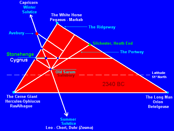
STONEHENGE and the CROSS of HEAVEN (CYGNUS)
We now take our large triangulation and draw a line connecting the two
midpoints of the two shortest lines of the major triangulation
(i.e. not the hypotenuse).
This line runs straight through Stonehenge.
We then create a small rectangle
by (1) connecting this new line to
Old Sarum with a line parallel to the short side of the large triangle.
and (2) drawing a perpendicular line from the new point just drawn
to the shortest side of the large triangle.
We draw the missing diagonal across the rectangle connecting
the corner points - it runs right through Stonehenge.
The result of this drawing shows an X within a rectangle with Stonehenge
at the middle of the two crossing diagonal lines.
With the Cerne Giant as the star Ras AlHague, The Long Man as Kappa
Orionis and the White Horse as the star Marked of the Great Square,
Stonehenge is thus exactly at the center of the Cross formed by Cygnus,
with the four corner stars of Cygnus equal to those of the small rectangle
on our map of Great Britain, so that, in the hermetic tradition,
it is on earth, as in heaven.
And now you know how they surveyed the building of "unique" Stonehenge.
THE STANDARD OF MEASURE USED FOR TRIANGULATION
According to Alexander Thom, "Megalithic Geometry in Standing Stones",
New Scientist, March 12, 1964, the megalithic "yard" was shorter than
the modern yard, and was equivalent to 2.72 (viz. 2.7) present English feet,
i.e. so that a megalithic foot was ca. 9/10ths of the present foot.
The triangulation using the Cerne Giant, The White Horse at Uffington and
the Long Man at Wilmington give approximate map-calculated values of 63
current
English miles for the shortest side of the triangulation (as the crow flies),
90 current English miles for the length of the middle side
and 110.25 current miles for the hypotenuse.
63 miles of current English feet are ca. 70 megalithic miles (63/.9)
[my calibration to the megalithic yard of Thom using a figure of 2.7]
and 90 current miles are ca. 100 megalithic "miles" (90/.9), so
that the hypotenuse would give ca. 122.50 megalithic miles based
on a calculation through the Pythagorean Theorem
(i.e. a-squared plus b-squared equal to c-squared.)
That the middle side of the triangulation is 100 megalithic miles supports
the general analysis, as does the comparable whole value of 70 megalithic
miles for the shortest side.
We WOULD expect surveyors to use such whole values.
Somewhat unexpected
- and unproven "numerology" until actual application can be proved -
is the conversion of 70 megalithic miles into
megalithic feet, giving a sum of ca. 364,000 megalithic feet,
so that every one thousand feet on the shortest
line of the triangulation was one day (a gigantic annual earthly day-dial?)
Similarly, the line of middle length, at 100 megalithic miles, would
be ca. 520,000 megalithic feet, i.e. one week of seven days every 10000 feet,
or a comparable value to 7 x 52 weeks = 364 days.
As noted in the Enc. Brit. for the Calendar of the Hebrews: "The mean
beginning
of the four seasons is called tequfa (literally "orbit," or "course"); the
tequfa of
Nisan denotes the mean Sun at the vernal equinox, that of Tammuz at the
summer solstice, that of Tishri at the autumnal equinox, and that of Tevet
at the winter solstice. As 52 weeks are equivalent to 364 days, and the
length of
the solar year is nearly 365 1/4 days, the tequfot move forward in the week
by
about 1 1/4 days each year."
I am no expert on Ley lines, but these may have had some measurement
role regarding the above calculations. Alfred Watkins coined the
term "Ley" for the famous lines and alleged that the Dod-men - e.g. the Long
Man
at Wilmington - were men with measuring sticks who measured the land,
since a Dod meant "to plow a straight line". I am sure Watkins was right. The
"Long Man" Dod-man at Wilmington is surely holding surveyor's rods.
If you look at your map of England, Watlington is 30 km East of the White
Horse
of Uffington, just south of Oxford.
If you connect this Isosceles Triangle Chalk Mark (known as the Watlington
White Mark)
with the Cerne Giant, your line will go straight through Stonehenge, at the
crossing
of the already crossed rectangle of Cygnus. The length of this line on my
ADAC map is 17 cm (scaled for 1 cm = 7.5 km). If you connect the Watlington
White mark with the Long Man as well, your line will also be 17 cm.
This is the (right) isosceles triangle represented by that chalk figure, i.e.
again the angle is just a tad more than 90 degrees. (The lengths of the
equal sides are ca. 85 megalithic miles.
(17cm x 7.5 = 127.5 km x .6 = 76.5 current miles / .9 = 85 megalithic miles)
But we already have an isosceles triangle in our previous triangulation,
formed
by the line from the Cenre Giant to Silechester (at the end of the Portway)
and
then down to the Long Man.
When we draw a straight line through the apex of both of these isosceles
triangles, the line for both triangles is PARALLEL to 0 degrees longitude.
(and nearly perpendicular to the base line). By chance, this is impossible.
Obviously, the ancients were adjusting their survey measures based on
a north-south as well as east-west orientation to account for
the curvature of the earth.
We can quibble about angles and distances, but the basic matter
seems settled.
This is a gigantic fantastic prehistoric survey.
P.S. The slope of the Watlington isosceles triangle is 44 degrees, a figure
we know from the construction of the Egyptian pyramids. I remain convinced
that both of these cultures are related. Also, my identification of the
Cerne Giant (a man with a club in his hand and an erect male organ) with
Hercules finds its comparable in my 1994 book, cited below, where I
equate the Pharaoh Kaiechos (whose hieroglyph consists of three ejaculating
male organs) with Hercules as well. The name Kaiechos for this Pharaoh is
Indo-European in origin, corresponding to Latvian term Kusis (long vowel u)
for the same organ.
In my book, "Kings and Dynasties" , Isandis Industries Inc., Lincoln, NE, USA,
1994, I noted at page 145: "This Graphic shows why Denebola was the "Nub" of
Heaven to the Great Square, both forming 90 degree angles to the other main
axis of Heaven running from Betelgeuse, the Biblical Beth-el, which crosses
to 180 degrees with Ras-al-Hague (Biblical Hai) at the left foot of Hercules."
Since I wrote that in 1994, I was not surprised to find this same main axis
at Stonehenge. Obviously, the two astronomical systems were related in origin.
Thanks to Andis Kaulins for the above information and pictures