| Nazca Art: Geometry in South America |
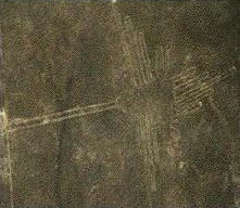
| The Nazca culture (dating to approximately 500 CE) is one of the most famous in the history of the Andes, because of the monumental scale of their "geoglyphs". (See map above for the location of the Nazca culture.) These large earth-works are immense in scale; the picture you see on the right is taken from the air. These lines were created by moving away the topsoil from the earth in the patterns you see here. Apparently this was not too difficult to do. However, the designs themselves must have taken immense efforts in planning. Think about how difficult it is just to walk in a perfectly straight line for a mile. What kinds of infrastructure do you think the Nazcas must have had to produce these large-scale works? | |
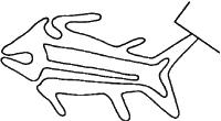
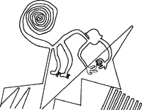
| We don't really know what these patterns signify, but scholars have suggested that these extremely straight lines were ritual walkways. Below are some drawings of the patterns. | |
| | |
| Another interesting thing about these geoglyphs is that there are many overlapping designs. In other words, later generations of Nazca peoples would create new shapes on the plains below the Andes mountains. Some of the designs are on hills, so that passers-by could see them. Most of the designs are on the flat land, where the overall image can only be discerned from the air. What might this mean for our understanding of how Nazca culture conceived of spatial relationships? In other words, how do you think Nazca culture incorporated geometry, distances, and even time into their world? What about their relationship to the universe and their gods? | |
Take a look at the technology used to analyze these glyphs!
Photometry Analysis of Hummingbird Geoglyph
Reference used for this page: